Part 1 of the 2024 Ultimate Staff Contest Blog Series
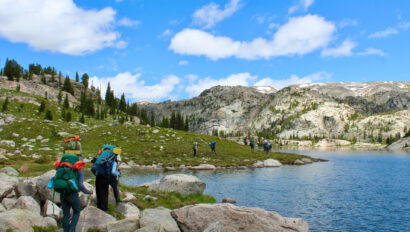
When you work for a company whose motto is “Do Something Wild”, your summers are guaranteed to be filled with quite the adventure. That could be kayaking around glaciers in Alaska, backpacking in the tundra surrounded by mountains, rafting down a river in Canada, ice climbing through waterfalls – or if you go on WA’s Alaska Southeast trip (which actually ventures into Canada, too!), all of those activities are packed into one epic trip.
So, when you are presented with the opportunity to design your own ultimate adventure, then you better go big. Pulling up a map on my computer, I immediately began looking south. South America was untouched to me, having never ventured further than Mexico. I went through the options of Columbia, then Peru, having heard of others’ great experiences in both. My eyes kept wandering further south, instinctively towards the distinctive mountains that lined the western edge. These wandering eyes along with some trail research landed me on one specific destination: Isla Navarino – the furthest south you could go. It is a Chilean island that is known to be the southernmost town, and on it is the southernmost trek in the world: Los Dientes de Navarino.

Soon I became consumed with researching the trail, deciding how many days it would take to do it, what the biggest challenges would be, and what gear would be needed. My other love and hobby is crafting, so to help it all come together, I bound a book and in it I put all the details of my adventure, drew a few maps, and watercolored what I imagined the mountains and the small town to look like, hoping someday soon I would actually see it all for myself.

We live in a world with easy access to an abundance of information. This is true for hiking as well. You can look at routes and reviews hikers leave on apps like All Trails. You can look up almost any hike online and find a YouTuber, Reddit poster, and blogger analyzing their experience of each day. Personally, when I travel to a new area, I don’t like to look at too many pictures or expose myself to too many details to keep the surprise factor alive. However, it is obviously necessary to read a few things to know what you are getting yourself into. From what I had read, Los Dientes Circuit is nothing too challenging in terms of mileage or elevation, however, the “trail” is only marked by cairns and occasional arrows, so trail finding and navigational awareness would be a priority. But there was one thing that was abundantly clear: the weather is unpredictable at all times. There were people saying that it could be sunny one minute and pouring – or snowing – the next. The wind is wild and some hikers have had to hunker down and wait it out before continuing on more treacherous parts of the trail where they could fall off the mountain if a big gust came blowing through.
Although this trek could have been done alone, the thought of having someone along with me was much more comforting and appealing. And who else would I invite besides my former WA co-leader from Alaska Southeast, Jake!

Together we had already learned we were good at balancing each other out in the backcountry, capable of being off trail, getting stuck in other countries, and enduring the unexpected. After many phone calls, double checking equipment, and deciding potential routes, we took off from opposite coasts of the US, soon to find each other in another country. The plan was to fly into Punta Arenas first. From there, you must take either a 45 minute flight or 32 hour ferry ride to the Isla Navarino. Even though the ferry had high reviews, I opted for the flight. When we landed, it was rainy and cold, which helped us understand what the weather might be like during our time on the island. Once you arrive on the island, it is a quick bus ride into town where we were dropped off right in front of Hostal Paso McKinley.


We were warmly welcomed by a kind woman running the place, as well as lit fireplaces encouraging us to stay. We set our bags down before we took a walk through town to get our last needed supplies such as fuel from Tourism Shila, snacks from Simon & Simon, and then a necessary check in at the police station to let them know our plans for the route. While we were in the police station we met a German couple that planned to head out the next day as well. From what we understood, there were about 13 people out on the trail currently, so we wouldn’t be alone.
As we were finishing packing up our bags back at the hostel, a couple, dressed top to bottom in rain gear, covered in mud, and clearly thrilled to be inside again came in. It was obvious that they were fresh off the trek, but did they finish it or not? They got settled in and after they both had warmed up and taken showers, I briefly talked to them in choppy English and Spanish. What I got out of it was that they had turned around after spending one night out there because of snow. It had snowed that day and trekking through it was too difficult. They decided to come back rather than venture on.
When I told Jake about the information I had collected, we sat there in a moment of silence. We knew we were going to have some weather, but didn’t realize it was snowing so much in the mountains.
“Well, we still are gonna try… right?” asked Jake.
“Of course.” And that was all that needed to be said. We went to bed, sticking to our plan to leave in the morning. There was very little that would have stopped us from going. We trusted that we both understood the importance of knowing when to not go, when to turn around, and how to address serious situations. After checking the weather and with each other once more, we stood strong in our decision to start the hike the morning of February 13th.

 With our bags packed and a nice breakfast at the hostel, we treated ourselves to a few empanadas at the supermarket that we planned to eat for lunch. Backpacks on and empanadas secured, we took off walking on the road towards the trailhead. Up and into the forest we went, one foot in front of the other, passing twisty trees covered in lichen and great big patches of moss that we thought looked like coral. We went far enough up that soon we were looking down on the little town of Puerto Williams and the Beagle Channel.
Now a few miles in and a substantial bit of elevation covered, we began to pass people. They all were turning back, some more positive than the others, but all set in their decision to return to town. They told us stories about the upcoming boulder fields covered in snow, the windy nights, and the cold temperatures that scared them away. One group after another passed by, but we kept trekking onwards. The snow that they were talking about seemed to be melting away and the rest of it all did not scare us – we were ready for an adventure.
By Mariah Reinke, WA Trip Leader